| Western Antarctica bedrock | Animation ID : AEA_2120 |
| PAL 4:3 | |
| PAL 16:9 | |
| HD 720 | |
| HD 1080 | |
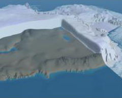
A spiral down over Antarctica, removing the ice to reveal the bedrock above sea level, then removing the water to reveal the seabed. Western Antarctica is revealed as a collection of islands.
Although occasionally pierced by high mountain chains, the Antarctic icecap is on average 2km thick. Seismic surveys have revealed the depth of the bedrock - much of it below sea level. Precise satellite-borne radar altimeter measurements enable the monitoring of changes to the slope and thickness of the icecap. Beneath the sea, parts of the continental shelf have been mapped by ice-breaking survey vessels. Seabed topography features distort the surface of the ocean, so they may also be charted by the satellite altimeter, which is sensitive enough to measure sea surface height to a few centimetres, even when it is covered by ice.
Data source: GTOPO30 digital terrain from US Geological Survey (USGS), ETOPO5 digital bathymetry from National Oceanic and Atmospheric Administration (NOAA), Antarctic bedrock topography provided by Alfred Wegener Institut (AWI) from a contour map by Scott Polar Research Institute (SPRI).
Credit : Planetary Visions Ltd.