


| Width | 3,500 pixels | |
| Height | 3,000 pixels | |
| 300 dpi print width | 11.7 inches | 29.6 centimetres |
| 300 dpi print height | 10.0 inches | 25.4 centimetres |
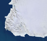
This image, extracted from the 250m Satellite Imagemap of Antarctica, shows Victoria Land, dicovered by Captain James Clark Ross in 1841 and named after Queen Victoria.
Based on images from the MODIS instrument on NASA's Terra satellite, with a pixel size of 250 metres, the mosaic was jointly developed by Planetary Visions in the UK and the German Aerospace Centre (DLR).
Based on images from the MODIS instrument on NASA's Terra satellite, with a pixel size of 250 metres, the mosaic was jointly developed by Planetary Visions in the UK and the German Aerospace Centre (DLR).