


| Width | 3,500 pixels | |
| Height | 3,000 pixels | |
| 300 dpi print width | 11.7 inches | 29.6 centimetres |
| 300 dpi print height | 10.0 inches | 25.4 centimetres |
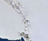
This extract from the 250m Satellite Imagemap of Antarctica shows the Byrd Glacier, about 136 km long and 24 km wide. The glacier, at the very centre of the image, drains the polar plateau and discharges into the Ross Ice Shelf.
Based on images from the MODIS instrument on NASA's Terra satellite, with a pixel size of 250 metres, the mosaic was jointly developed by Planetary Visions in the UK and the German Aerospace Centre (DLR).
Based on images from the MODIS instrument on NASA's Terra satellite, with a pixel size of 250 metres, the mosaic was jointly developed by Planetary Visions in the UK and the German Aerospace Centre (DLR).