Data Gaps
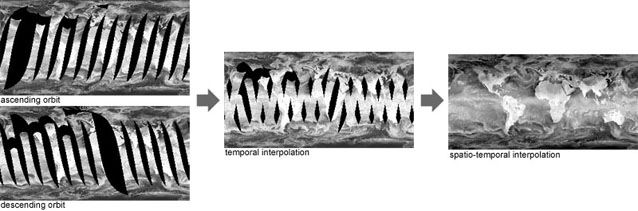
Operational satellite systems such as weather satellites orbit the globe continually acquiring images. A different part of the globe is imaged on each orbit, and several orbits are needded to build a picture of the entire Earth, sometimes requiring days or weeks to achieve. One day's orbits will typically have gaps in the data coverage due to the geometry of the sensor, or due to satellite activities such as data download which interrupt the image acquisition (above left).
Scientists analysing the data can simply flag missing data, but it can be very distracting when presented to the general public. We have developed techniques to "clean up" gaps in a data sequence by interpolating both spatially within each image, and temporally between images, to give the clearest possible visualisation of the data (right).